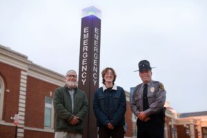
Campus safety is always on the mind of University of Mary Washington Chief of Police Michael Hall, and now, thanks to a partnership with faculty and a student researcher, there’s a map to support it.
The project began with a chance encounter between Hall and Professor of Biological Sciences Alan Griffith, who had previously mapped trees across campus. Together, they wondered if the same technology could be used to plot a key aspect of UMW’s emergency phone system: the glowing blue lights that offer a one-touch connection to university police.
Griffith knew just the student to bring it to life—Jillian Rosenquist, a junior environmental science major pursuing a geographic information systems (GIS) certificate. Together, the trio visualized a blueprint for campus safety. “Campus safety is a shared responsibility between students, police and the community,” Hall said. “This project was community policing at its finest.”
Mary Washington’s emergency phone system includes nearly 90 blue light phones mounted to poles or bases at exterior locations across campus, such as along sidewalks and walkways, in parking lots and near buildings. Mapping their locations helps improve efficiency and reduce redundancy, or, as Hall explains, “identifies where there may be too many blue lights or where they may be too close together or too far apart.”
Griffith said the project ensures accessibility for everyone on campus and helps the UMW Department of Police and Public Safety monitor operations and maintenance. “When GIS-based emergency phone maps are used to their potential, the UMW campus is a safer place,” Griffith said.
At the start of the semester, Griffith and Rosenquist began the mapping process. While Griffith provided oversight, Rosenquist completed most of the work independently. “I knew Jill would be great for this project,” Griffith said. “She brought valuable experience, having already completed an introductory GIS course.”
Drawing on that expertise, Rosenquist worked to make the maps more current, readable and dynamic. She built a geodatabase for each blue light phone using ArcGIS Pro, a desktop application that allows users to visualize, analyze and manage spatial data. She then used a combination of platforms, including ArcGIS Online and ArcGIS Field Maps to record and verify the precise locations of each phone.
“My GIS background played a significant role in this project,” Rosenquist said. “Seeing how it applies in a real-world setting helped me understand its value and versatility.”


She went on to present her findings at a Jepson Science Center Symposium, highlighting the project’s contribution to campus safety and its lasting impact. “My goal was for this project to help provide comfort for students,” she said. “Especially for freshmen who are new to college life.”
Because of her work with Hall and Griffith, Rosenquist earned a summer internship with the U.S. Architect of the Capitol (AOC), where she mapped garden beds for the Capitol Grounds and Arboretum (CGA). Using a similar database structure to the blue light project, she created detailed attributes for each garden bed, allowing CGA landscaping crews to implement a universal labeling system and streamline maintenance across the Capitol grounds.
At the end of her internship, Rosenquist presented her work to CGA Executive Director Jim Kaufmann and division managers within the AOC, who continue to utilize the maps she developed.
“I know the skills I gained during the blue light project were a deciding factor when I was offered the summer internship,” Rosenquist said. “I’m incredibly grateful I was given the opportunity to help with that project.”
Hall was equally grateful to work with such a dedicated team, reflecting on how a small encounter turned into a collaboration that benefits the entire UMW community.
“I was blown away by Jill’s professionalism and the quality of her work,” he said. “Instead of hiring an outside team, we achieved the same results by involving our own students, faculty and staff, generating a successful outcome and powerful learning experience.”
Find maps of the emergency phones, called blue light phones, on all three UMW campuses.